


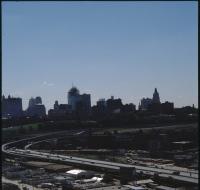
View above Interstate 35
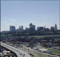
Aerial view of Kansas City from above Interstate 35 looking east. The interstate is curving to the left next to a series of railroad tracks. Industrial facilities are on the right as well. Skyscrapers...
View from Broadway Boulevard
Aerial view of Kansas City from above Broadway Boulevard looking north. The headquarters for Veterans for Foreign Wars and Our Lady of Perpetual Help Parish are on the left along Broadway. Downtown...
View from Broadway Boulevard

Aerial view of Kansas City from above Broadway Boulevard looking north. The headquarters for Veterans for Foreign Wars and Our Lady of Perpetual Help Parish are on the left along Broadway. Downtown...
View from Broadway Boulevard

Aerial view of Kansas City from above Broadway Boulevard looking north. The headquarters for Veterans for Foreign Wars and Our Lady of Perpetual Help Parish are on the left along Broadway. A large...
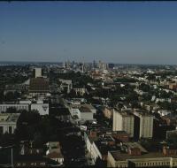
View from Broadway Boulevard
Aerial view of Kansas City from above Broadway Boulevard looking north. Houses are along the left side and foreground. Two large radio antennas are on the left and right side. Downtown Kansas City is...
View from Highway 35

Aerial view of Kansas City above Interstates 35 and 670 looking east. Skyscrapers, parking lots, and downtown Kansas City are visible across from the highway The sun is setting and casting large...
View from Highway 35

Aerial view of Kansas City above Interstates 35 and 670 looking east. Skyscrapers, parking lots, and downtown Kansas City are visible across from the highway The sun is setting and casting large...
View from Highway 71

Aerial view of Kansas City above highway 71 looking west. Skyscrapers, parking lots, and downtown Kansas City are visible across from highway 71. Warehouses and factories are on the other side of the...
View from Highway 71

Aerial view of Kansas City above highway 71 looking west. Skyscrapers, parking lots, and downtown Kansas City are visible across from highway 71. Warehouses and factories are on the other side of the...
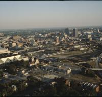
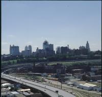
View from Southwest Boulevard
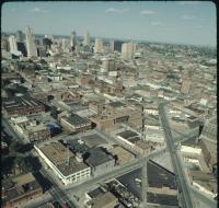
Aerial view of Kansas City above Southwest Boulevard looking northeast. Skyscrapers and downtown Kansas City are visible on the left. Dozens of warehouses and office buildings are spread throughout...
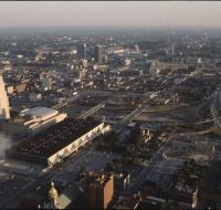
View from the Convention Center

Aerial view of Kansas City looking southeast. Interstate 670 is passing under several road bridges and intersects with Interstate 35 on the right. The Convention Center, Municipal Auditorium, and...
View from the Convention Center
Aerial view of Kansas City looking southeast. Interstate 670 is passing under several road bridges and intersects with Interstate 35 on the right. The Convention Center, Municipal Auditorium, and...
View from the Convention Center
Aerial view of Kansas City looking southeast. Interstate 670 is passing under several road bridges and intersects with Interstate 35 on the right. The Convention Center, Municipal Auditorium, and...
View from the Convention Center
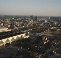
Aerial view of Kansas City above the Convention Center looking southeast. Interstate 670 is passing under several road bridges and intersects with Interstate 35 on the right. The Convention center has...
View from the Convention Center

Aerial view of Kansas City above the Convention Center looking southeast. Interstate 670 is passing under several road bridges and intersects with Interstate 35 on the right. The Convention center has...
View from the Convention Center

Aerial view of Kansas City above the Convention Center looking southeast. Interstate 670 is passing under several road bridges. The Convention center has a dark, flat roof. The Municipal Auditorium is...
View from Westport neighborhood
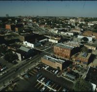
Aerial view of Kansas City from the Westport neighborhood looking north. Several parking lots are in the foreground next to warehouses and office buildings. Skyscrapers and downtown Kansas City are...
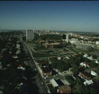
View of Penn Valley area
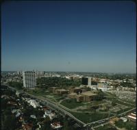
Aerial view of the BMA building, also known as One Park Place, and Penn Valley Community College in the midtown Kansas City area. There are houses along the bottom. Skyscrapers and downtown Kansas...
View of Penn Valley area
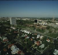
Aerial view of the BMA building, also known as One Park Place, and Penn Valley Community College in the midtown Kansas City area. There are houses along the bottom. Skyscrapers and downtown Kansas...
View of the Kansas City skyline

Aerial view of the Kansas City skyline and the West Bottoms area. Factories and warehouses are on both sides of Main Street. Skyscrapers and downtown Kansas City is visible in the distance. There is...
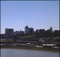
View of the West Bottoms
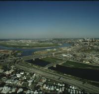
Aerial view of the West Bottoms area of Kansas City where the Kansas River and Missouri Rivers converge. Interstates 70 and 35 cross the Kansas River heading toward downtown Kansas City in the...
West Bottoms of Kansas City
Aerial view looking southeast over Interstate 70 in the West Bottoms area. Skyscrapers and downtown Kansas City are visible in the distance. There are warehouses and factories near the highway. The...
West Bottoms of Kansas City
Aerial view looking east over Interstate 70 in the West Bottoms area. Skyscrapers and downtown Kansas City are visible in the distance. There are warehouses and factories on both sides of the highway...
West Bottoms of Kansas City
Aerial view looking east over Interstate 70 in the West Bottoms area. Skyscrapers and downtown Kansas City are visible in the distance. There are warehouses and factories on both sides of the highway.
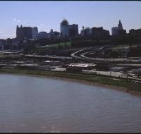
West Bottoms of Kansas City
Aerial view looking southeast over the Missouri River in the West Bottoms area. Skyscrapers and downtown Kansas City are visible in the distance. There are warehouses and factories near Interstate 70...