


Aerial view above Wheeler Airport
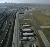
Aerial view above Wheeler Airport in Kansas City, Missouri. Two airport runways are on the right next to several terminal buildings. Trains are moving along a network of railroad tracks on the left...
Aerial view of a suburban area

Aerial view of a residential neighborhood in suburban Kansas City. An apartment complex is at the bottom and several groups of houses are on the other side of a road. Two radio antennae and downtown...
Aerial view of a suburban area
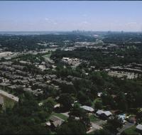
Aerial view of a suburban area near Kansas City. Houses are along several grids of roads. Downtown Kansas City is in the distance along the skyline.
Aerial view of an industrial area
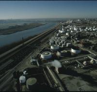
Aerial view of an industrial area along the Missouri River. Storage tanks are scattered along lots next to a railroad line that runs parallel to the river. Skyscrapers and downtown Kansas City are...
Aerial view of an industrial district

Aerial view of an industrial district north of downtown Kansas City. Several road bridges are crossing the Missouri River. Skyscrapers and downtown are visible in the distance on the other side of the...
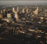
Aerial view of downtown
Aerial view of downtown Kansas City looking southwest. There are apartment buildings and warehouses on the other side of a highway from skyscrapers. The Missouri river is passing behind downtown...
Aerial view of downtown
Aerial view of downtown Kansas City looking north above Interstate 670. The highway passes underneath several road bridges. There are over a dozen skyscrapers north of the highway. The Missouri River...
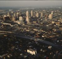
Aerial view of downtown Kansas City
Aerial view of downtown Kansas City near the intersection of Interstate 670 and Highway 71 looking northwest. Interstate 670 passes below road bridges into downtown. Skyscrapers and large parking lots...
Aerial view of downtown Kansas City
Aerial view of downtown Kansas City looking southwest. The Missouri River passes in front of downtown. Skyscrapers are visible in the distance. Warehouses and industrial facilities are visible in...
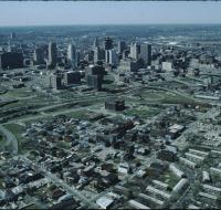
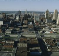
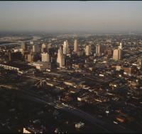
Aerial view of downtown Kansas City

Aerial view of downtown Kansas City. Skyscrapers are surrounded by dozens of blocks with retail and office buildings. Interstate 670 passes in front of the skyscrapers. The Missouri River is in the...
Aerial view of downtown Kansas City

Aerial view of downtown Kansas City. Skyscrapers are surrounded by dozens of blocks with retail and office buildings. Interstate 670 passes in front of the skyscrapers. The Missouri River is in the...
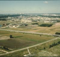
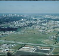
Aerial view of fields
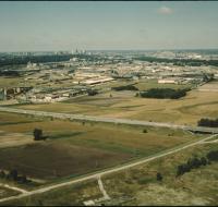
Aerial view of fields and an industrial park near Kansas City. Skyscrapers and downtown Kansas City are visible on the skyline. A highway is passing through the fields. Warehouses are on the other...
Aerial view of fields
Aerial view of fields and an industrial park near Kansas City. Skyscrapers and downtown Kansas City are visible on the skyline. A highway is passing through the fields. Warehouses are on the other...
Aerial view of industrial facilities

Aerial view of an industrial area near downtown Kansas City. There are houses in between trees at the bottom of the photo. Warehouses and railroad tracks are in front of the downtown area. Skyscrapers...
Aerial view of industrial facilities
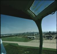
Aerial view of industrial facilities through a helicopter window. Factories and warehouses are in the foreground. Skyscrapers and downtown Kansas City are in the distance.
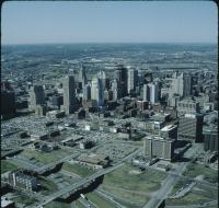
Aerial view of Kansas City
Aerial view of Kansas City above the intersection of Interstates 35 and 670 looking east. Downtown is on the left, including the Convention Center, Municipal Auditorium, and Kansas City Power and...
Aerial view of Kansas City
Aerial view of Kansas City above Interstate 35 looking northeast. Skyscrapers, parking lots, and downtown Kansas City are visible in the center. There are office buildings and houses spread to the...
Aerial view of Kansas City
Aerial view of Kansas City looking northeast toward downtown. Interstate 35 is passing north over Interstate 670. The Missouri River is visible in the distance on the left. The Convention Center is on...
Aerial view of Kansas City
Aerial view of Kansas City looking northeast toward downtown. Interstate 35 is passing north over Interstate 670. The Missouri River is visible in the distance on the left. The Convention Center is on...
Aerial view of Kansas City
Aerial view of Kansas City above Interstates 35 and 670 looking northeast. Skyscrapers, parking lots, and downtown Kansas City are visible across from the highway. The Convention Center, Municipal...
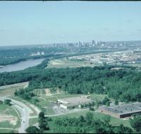
Aerial view of Kansas City
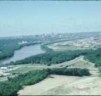
Aerial view of Kansas City above land under development looking south. The Missouri River is passing under a small bridge on the left. Downtown Kansas City is visible in the distance. The area in the...
Aerial view of Kansas City
Aerial view of Kansas City from the north. There are open fields and warehouses in the foreground. The Missouri River and downtown Kansas City are in the distance.
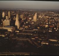
Aerial view of Kansas City

Aerial view of Kansas City looking south, likely from City Hall building. The Bolling Federal building is on the left. The Jackson County Courthouse is in the center. Interstate 670 is behind the...
Aerial view of Kansas City
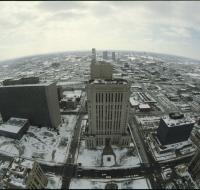
Aerial view of Kansas City looking south, likely from City Hall building. The Bolling Federal building is on the left. The Jackson County Courthouse is in the center. Interstate 670 is behind the...
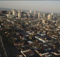
Aerial view of Kansas City
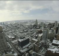
Aerial view of Kansas City looking south, likely from City Hall building. The Jackson County Courthouse is on the left. Dozens of other skyscrapers and office buildings are on the right. Interstate...