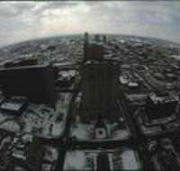
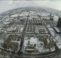
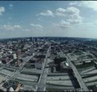
"K.C. Strip" N. Side 12th St, Wyandotte - Central Now Vista Hotel site
View of the shops including Peyton Place, the IT Club, and the Can Can Cocktail Lounge in the "K.C. Strip" on the north side of 12th St.
View of empty lot at southwest corner of 10th and Main with New York Life Building in background and crown Christmas decoration hanging from light...
View of "K.C. Strip" at 12th and Wyandotte from Barney Allis Plaza.
View of 12th St. looking south from Wyandotte showing excavation for City Center Square.
Street view of 12th & McGee from the drivers side of a car stopped at a red light showing pedestrians, street cars, cars, and the exterior of the...
Stone Façade of "Old Nelson" building slated for demolition to build the 6th street expressway.
View east on 9th street looking toward Walnut. Fidelity Bank on right.
Aerial view above Wheeler Airport in Kansas City, Missouri, overlooking the confluence of the Missouri and Kansas Rivers. A road bridge is crossing...
Aerial view above Wheeler Airport in Kansas City, Missouri. Two airport runways are on the right next to several terminal buildings. Trains are moving...
Aerial view of an industrial area along the Missouri River. Storage tanks are scattered along lots next to a railroad line that runs parallel to the...
Aerial view of Kansas City looking south, likely from City Hall building. The Bolling Federal building is on the left. The Jackson County Courthouse...
Aerial view of Kansas City looking south from atop a building in downtown. Several large office buildings are scattered between large parking lots...
Aerial view of Kansas City looking south, likely from City Hall building. The Jackson County Courthouse is on the left. Dozens of other skyscrapers...
Aerial view of Kansas City from atop a building in downtown. Several skyscrapers are scattered between office buildings and parking lots. Cars are...
Aerial view of Kansas City looking northeast from a downtown skyscraper. Several parking lots are in front. Cars are driving along the roads. A white...
Aerial view of Kansas City looking north from atop the Power & Light building. Several parking lots are on the right. Cars are driving along the roads...
Aerial view of Kansas City looking northeast from atop the Power & Light building. Several parking lots are in the foreground. Cars are driving along...
Aerial view of Kansas City looking south from the Power & Light district. Interstate 670 passes underneath several road bridges. Office buildings and...