


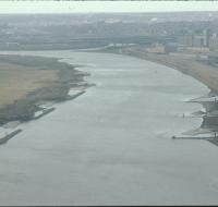
Aerial view of the Missouri River

Aerial view of the Missouri River and nearby buildings. There are sandbars and berms along each side of the river. Factories and industrial storage facilities are on the right. Railroad tracks run...
Aerial view of the Missouri River

Aerial view of the Missouri River and nearby buildings. There are sandbars and berms along each side of the river. Factories and industrial storage facilities are on the right.
Aerial view of the Missouri River
Aerial view of the Missouri River and nearby buildings. There are sandbars and berms along each side of the river. Factories and industrial storage facilities are on the right.
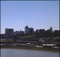
View from Highway 71

Aerial view of Kansas City above highway 71 looking west. Skyscrapers, parking lots, and downtown Kansas City are visible across from highway 71. Warehouses and factories are on the other side of the...
View from Highway 71

Aerial view of Kansas City above highway 71 looking west. Skyscrapers, parking lots, and downtown Kansas City are visible across from highway 71. Warehouses and factories are on the other side of the...
View of the West Bottoms
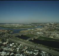
Aerial view of the West Bottoms area of Kansas City where the Kansas River and Missouri Rivers converge. Interstates 70 and 35 cross the Kansas River heading toward downtown Kansas City in the...
West Bottoms of Kansas City
Aerial view looking southeast over Interstate 70 in the West Bottoms area. Skyscrapers and downtown Kansas City are visible in the distance. There are warehouses and factories near the highway. The...
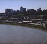
West Bottoms of Kansas City
Aerial view looking southeast over the Missouri River in the West Bottoms area. Skyscrapers and downtown Kansas City are visible in the distance. There are warehouses and factories near Interstate 70...