


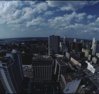
Aerial view of Kansas City

Aerial view of Kansas City looking north from atop the Power & Light building. Several parking lots are on the right. Cars are driving along the roads. There are dozens of skyscrapers and office...
Aerial view of Kansas City
Aerial view of Kansas City looking northeast from atop the Power & Light building. Several parking lots are in the foreground. Cars are driving along the roads. There are dozens of skyscrapers and...
Aerial view of Kansas City
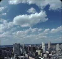
Aerial view of Kansas City looking northeast from atop the Power & Light building. Several parking lots are in the foreground. Cars are driving along the roads. There are dozens of skyscrapers and...
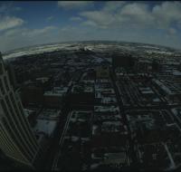
Aerial view of Kansas City
Aerial view of Kansas City looking south from the Power & Light district. Interstate 670 passes underneath several road bridges. Office buildings and warehouses are on the other side of the highway.
Aerial view of Kansas City
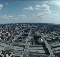
Aerial view of Kansas City looking south from the Power & Light district. Interstate 670 passes underneath several road bridges. Office buildings and warehouses are on the other side of the highway.
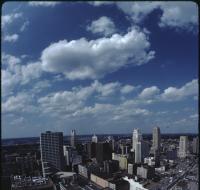
Aerial view of Kansas City
Aerial view of Kansas City looking north from atop the Power & Light building. Several parking lots are on the right. Cars are driving along the roads. There are dozens of skyscrapers and office...
Aerial view of Kansas City
Aerial view of Kansas City looking east from a downtown skyscraper. Several parking lots are in front. Cars are driving along the roads. One skyscraper is on the left. All the buildings and lots are...
Aerial view of Kansas City
Aerial view of Kansas City looking east from a downtown skyscraper. Several parking lots are in front. Cars are driving along the roads. One skyscraper is on the left. All the buildings and lots are...
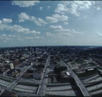
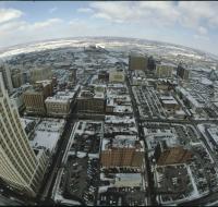
Aerial view of Kansas City

Aerial view of Kansas City looking south from the Power & Light district. Interstate 670 passes underneath several road bridges. Office buildings and warehouses are on the other side of the highway.
Aerial view of Kansas City
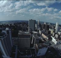
Aerial view of Kansas City looking north from atop the Power & Light building. Several parking lots are on the right. Cars are driving along the roads. There are dozens of skyscrapers and office...
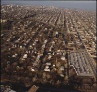
Aerial view of Manheim neighborhood

Aerial view of the Manheim neighborhood in Kansas City near Volker Boulevard, Troost Avenue, and Paseo Boulevard. Troost and Paseo are running north and south near the center of the photo. There are...
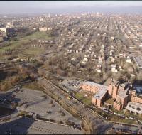
Aerial view of Menorah Medical Center
Aerial view of Menorah Medical Center and other buildings along Brush Creek in Kansas City. Menorah Medical Center is at the bottom in-between Rockhill Road and Volker Boulevard. Downtown Kansas City...
Aerial view of Menorah Medical Center and the Nelson-Atkins Art Museum
Aerial view of Menorah Medical Center and other buildings along Brush Creek in Kansas City. Menorah Medical Center is at the bottom right in-between Rockhill Road and Volker Boulevard. The Nelson...
Aerial view of Nelson-Atkins lawn
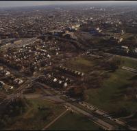
Aerial view the front lawn of the Nelson-Atkins Museum of Art in Kansas City looking south. The lawn ends at Brush Creek and Volker Boulevard. The campus for University of Missouri-Kansas City is on...
Aerial view of offices and warehouses
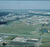
Aerial view of office parks and warehouses near Kansas City. A highway passes along the bottom. Several sets of warehouses are in the center alongside roads. Office buildings are along the roads as...
Aerial view of offices and warehouses
Aerial view of office parks and warehouses near Kansas City. A highway passes along the bottom. Several sets of warehouses are in the center alongside roads. Office buildings are along the roads as...
Aerial view of offices and warehouses
Aerial view of office parks and warehouses near Kansas City. A highway passes along the bottom. Several sets of warehouses are in the center alongside roads. Office buildings are along the roads as...
Aerial view of offices and warehouses

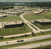
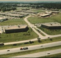
Aerial view of office parks and warehouses near Kansas City. A highway passes from the right into the distance. Several sets of warehouses are in the center alongside roads. Office buildings are along...
Aerial view of offices and warehouses
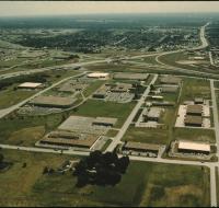
Aerial view of office parks and warehouses near Kansas City. A highway passes from the left into the distance. Several sets of warehouses are in the center alongside roads. Office buildings are along...
Aerial view of offices and warehouses
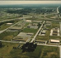
Aerial view of office parks and warehouses near Kansas City. A highway passes from the left into the distance. Several sets of warehouses are in the center along side roads. Office buildings are along...
Aerial view of Plaza region

Aerial view the Country Club Plaza region in Kansas City looking north. The Intercontinental hotel is in the center overlooking Brush Creek at the intersection of Volker Boulevard and Wornall Road...
Aerial view of the Kansas River
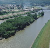
Aerial view of an island in the Kansas River. The island is covered with trees. Behind the island is a railroad bridge crossing the river. There are houses and a water tower on the other side of the...
Aerial view of the Kansas River

Aerial view of an island in the Kansas River. The island is covered with trees. Behind the island is a railroad bridge crossing the river. There are houses and a water tower on the other side of the...
Aerial view of the Missouri and Kansas Rivers
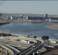
Aerial view of the confluence of the Missouri and Kansas Rivers near the West Bottoms in Kansas City. There is a large factory on the far side of the river. A series of highway ramps are at the bottom...
Aerial view of the Missouri and Kansas Rivers
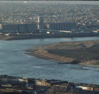
Aerial view of the confluence of the Missouri and Kansas Rivers near the West Bottoms in Kansas City. There is a large factory on the far side of the river. Smaller warehouses are at the bottom of the...